The north and east sections of the FBP are dominated by sandstone; the south is dominated by deep heavy grey and brown cracking clays. The Australian Natural Resources Atlas[1] has more detailed geological descriptions about the various vegetation bioregions composing the WCG FBP:
Cape York Peninsula consists of complex geology dominated by the Torres Strait Volcanics in the north. South of the region has deeply dissected sandstone plateaus and flat plains of colluvial and alluvial clays, silts, and sands. West of the region contains extensive sand sheets.
Einasleigh Uplands consists of high ranges and plateau surfaces of palaeozoic sediments, granites, and basalts. The region generally has diverse geology ranging from mesozoic sandstones occurring as small plateaus, alluvium, permian granites palaeozoic sediments, acid volcanics and rugged ranges on folded sediments and igneous rocks.
The Mitchell Grass Downs are characterised by undulating downs on shales and limestones. The soils are predominantly deep heavy grey and brown cracking clays often with self-mulching and sometimes stony surfaces. The plains are interspersed with drainage lines.
HIDE THIS SECTION
Terrain
Relief ratio
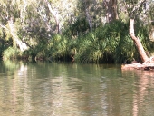
Photo by Water Planning Ecology Group, DSITIA
The Western Cape and Gulf has, on average, a low relief ratio, with a mean for the FBP of 0.013. High relief ratio areas are spread throughout the east of the FBP. Stream segment slope values are also low, with higher values corresponding to areas with high relief ratio values.
The FBP is dominated by the erosional and valley bottom flatness index classes, both of which dominate different regions of the FBP. A small proportion of the FBP contains ridge top flat areas, which occupy the borders between erosional and valley bottom flat areas.
Department of Environment, Science and Innovation, Queensland (2013) Western Cape and Gulf Freshwater Biogeographic Province – Geology and topography, WetlandInfo website, accessed 14 April 2025. Available at: https://wetlandinfo.des.qld.gov.au/wetlands/ecology/aquatic-ecosystems-natural/riverine/freshwater-biogeo/western-cape-and-gulf/geology-topography.html


 — Department of the Environment, Tourism, Science and Innovation
 HIDE THIS SECTION
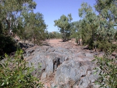
") .
.