Quick facts
- Undara Lava Tubes
- in far north Queensland is a groundwater dependent cave system formed by lava. These cave systems can fill with water during floods and hold water during dry times[1].
- Plants
- often use groundwater that we can't see. This vegetation is part of a groundwater dependent ecosystem.
Wetland system classification
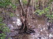
Estuarine wetlands are those with oceanic water sometimes diluted with freshwater run-off from the land.
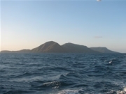
Marine wetlands include the area of ocean from the coastline or estuary, extending to the jurisdictional limits of Queensland waters (3 nautical mile limit). This definition differs from that in Ramsar, as it includes waters deeper than 6m below the lowest astronomical tide.
Lacustrine wetlands are large, open, water-dominated systems (for example, lakes) larger than 8ha. This definition also applies to modified systems (for example, dams), which are similar to lacustrine systems (for example, deep, standing or slow-moving waters).
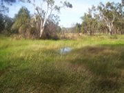
Palustrine wetlands are primarily vegetated non-channel environments of less than 8 hectares. They include billabongs, swamps, bogs, springs, soaks etc, and have more than 30% emergent vegetation.
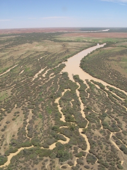
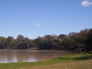
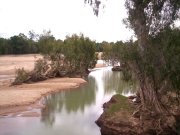
Riverine wetlands are all wetlands and deepwater habitats within a channel. The channels are naturally or artificially created, periodically or continuously contain moving water, or connecting two bodies of standing water.
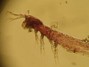
Subterranean wetlands are wetlands occurring below the surface of the ground and that are fed by groundwater i.e. caves and aquifers. These wetlands provide water to groundwater dependent ecosystems.
|
|
Riverine wetlands are all wetlands and deepwater habitats within a channel. The channels are naturally or artificially created, periodically or continuously contain moving water, or connecting two bodies of standing water.
|
Lacustrine wetlands are large, open, water-dominated systems (for example, lakes) larger than 8ha. This definition also applies to modified systems (for example, dams), which are similar to lacustrine systems (for example, deep, standing or slow-moving waters).
|
|
Palustrine wetlands are primarily vegetated non-channel environments of less than 8 hectares. They include billabongs, swamps, bogs, springs, soaks etc, and have more than 30% emergent vegetation.
|
Marine wetlands include the area of ocean from the coastline or estuary, extending to the jurisdictional limits of Queensland waters (3 nautical mile limit). This definition differs from that in Ramsar, as it includes waters deeper than 6m below the lowest astronomical tide.
|
|
Estuarine wetlands are those with oceanic water sometimes diluted with freshwater run-off from the land.
|
Subterranean wetlands are wetlands occurring below the surface of the ground and that are fed by groundwater i.e. caves and aquifers. These wetlands provide water to groundwater dependent ecosystems.
|
| |
Wetland on-line education modules
A series of on-line education modules, including What is a wetland?, has been prepared as a resource for people who want to learn more about wetlands.
Users can download and use the contents of this education module to meet their learning and training needs. This information should be used in conjunction with information found on this website.
This resource outlines the key principles of a wetland defination and should not be used for statutory purpose.
For definitions of intertidal and subtidal wetland systems see the Queensland Wetland Definition Guideline.
References
- ^ Nielsen, D, Brock, M, Rees, G & Baldwin, D (2003), 'Effects of increasing salinity on freshwater ecosystems in Australia', Australian Journal of Botany, vol. 51, p. 655.
Last updated: 12 May 2015
This page should be cited as:
Department of Environment, Science and Innovation, Queensland (2015) Wetland systems, WetlandInfo website, accessed 8 May 2025. Available at: https://wetlandinfo.des.qld.gov.au/wetlands/what-are-wetlands/definitions-classification/system-definitions.html


 — Department of the Environment, Tourism, Science and Innovation