Skip links and keyboard navigation

Queensland Government
WetlandInfo   —   Department of the Environment, Tourism, Science and Innovation

Lake Eyre Basin River Health Assessment

HIDE THIS SECTION
Coverage

The map below highlights the areas where sampling has occurred for this program.

Click on the map to view information about the drainage basins in this area.

Download points KML (KMZ, 0.1 MB) metadata


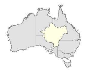
The Lake Eyre Basin River Health Assessment is an inter-governmental monitoring program. The Department of the Environment, Tourism, Science and Innovation conducts monitoring in the Queensland component of the Lake Eyre Basin.  

HIDE THIS SECTION
Program start date

2011

HIDE THIS SECTION
Program end date

Review of program 10 years from commencement

HIDE THIS SECTION
Objectives of the program

To gain an understanding of the Lake Eyre Basin condition in order to:

  • underpin responses to condition
  • form consistent messages about condition
  • guide ongoing research, investigation and monitoring efforts.

HIDE THIS SECTION
Who is involved?

Lead organisation

Department of Natural Resources and Mines

water.monitoring@dnrm.qld.gov.au

Partner organisations

South Australian Government, Northern Territory Government and the Commonwealth Government

Contact details of lead organisation:

HIDE THIS SECTION
List of indicators monitored

Fish assemblages

  • Species richness
  • Abundance
  • Abundance of alien species
  • Recruitment
  • Population size structure
  • Abundance of detritivores
  • Prevalence of disease

Waterbirds (not included at present)

  • Total abundance of colonial waterbirds
  • Species richness of colonial waterbirds
  • Abundance of functional groups of waterbirds
  • Community composition
  • Presence/absence of particular species
  • Abundance of breeding birds
  • Species richness of breeding birds

Vegetation (not included at present)

  • % cover of 3-5 dominant woody species in upper and middle (layers)
  • % herbaceous ground cover
  • % cover aquatic vegetation (submerged, floating, emergent)
  • % cover of exotics
  • Native regeneration
  • Width of riparian zone
  • Longitudinal connectivity

Vegetation (nationally important wetlands) – (not included at present)

  • Floristic composition
  • Species richness
  • % foliage cover of understorey species
  • % canopy cover
  • Foliage cover
  • Height ranges of vegetation layers (trees, shrubs, understorey)
  • Tree vigour
  • Population size structure

Physical habitats – (not included at present)

  • Physical diversity
  • Channel instability

Water Quality – (spot readings only)

  • Conductivity
  • pH
  • Dissolved oxygen (diel range)
  • Turbidity
  • Water temperature (diel range)

Hydrology – (data from gauging stations and data loggers)

  • Total surface water availability
  • Water storage capacity
  • Water licensing
  • Filling of terminal lakes
  • Floodplain inundation
  • In-channel events
  • Persistence of key waterholes

HIDE THIS SECTION
Scale of program

Basin scale

HIDE THIS SECTION
Brief description of sampling locations

  • Fish assemblage - 82 sites, 28 in Queensland
  • Waterbirds - expansion of Eastern aerial waterbird survey transects
  • Vegetation (riparian) - 82 sites
  • Vegetation (nationally important wetlands) - 28 sites
  • Physical habitats - as per fish assemblage sites
  • Water quality - as per fish assemblage sites
  • Hydrology - as per fish assemblage sites

HIDE THIS SECTION
Frequency of monitoring

Annual base monitoring, mid-term assessment in fifth year and full assessment in tenth year

HIDE THIS SECTION
Where is the program reported?


Last updated: 22 March 2013

This page should be cited as:

Department of Environment, Science and Innovation, Queensland (2013) Lake Eyre Basin River Health Assessment, WetlandInfo website, accessed 15 April 2025. Available at: https://wetlandinfo.des.qld.gov.au/wetlands/assessment/monitoring/current-and-future-monitoring/lake-eyre-basin-river-health.html